AUDIO-GIDA, Laburpena eta ahotsa, Antton (5 minutu)
AUDIO-GUIDE Spanish (Sintetizada) 5 minutos
AUDIO-GUIDE ENGLISH (Sintetizada) 1:30 minutos


AUDIO-GIDA, Laburpena eta ahotsa, Antton (5 minutu)
AUDIO-GUIDE Spanish (Sintetizada) 5 minutos
AUDIO-GUIDE ENGLISH (Sintetizada) 1:30 minutos

By Idoia Filloy Nieva and Eliseo Gil Zubillaga
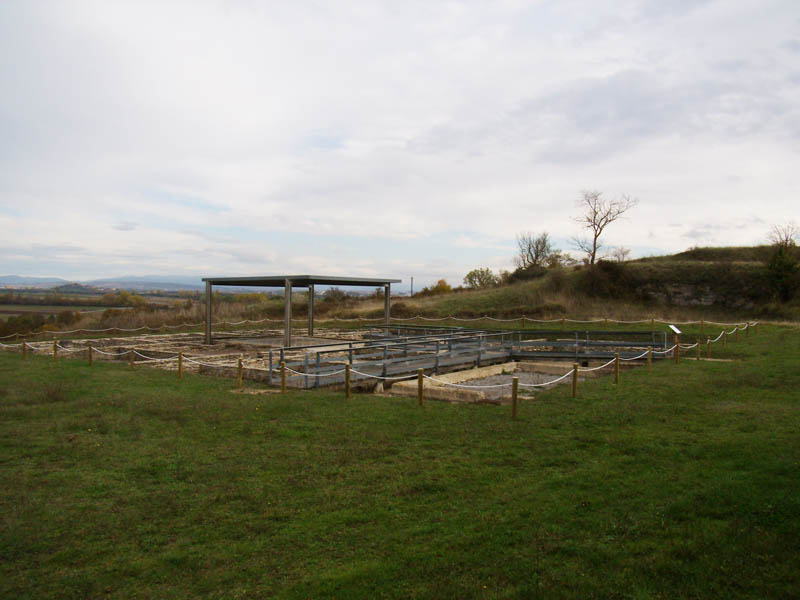
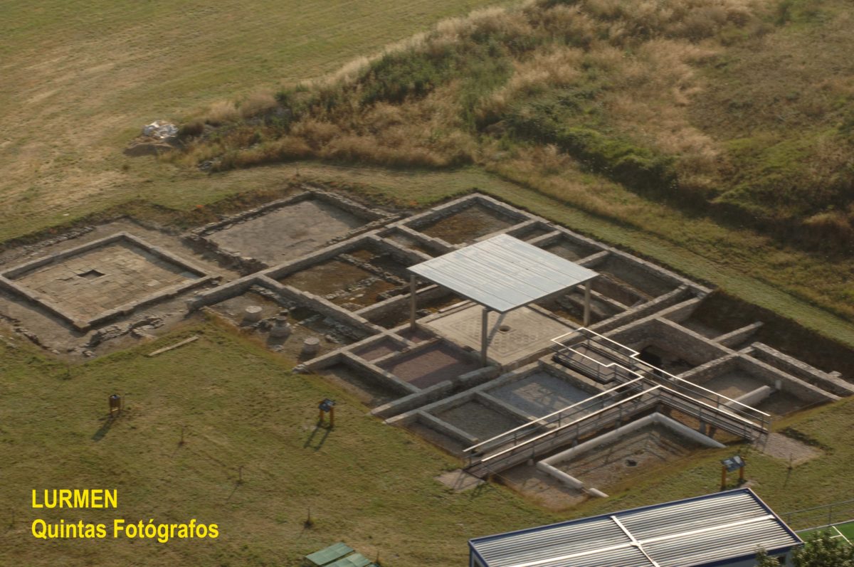
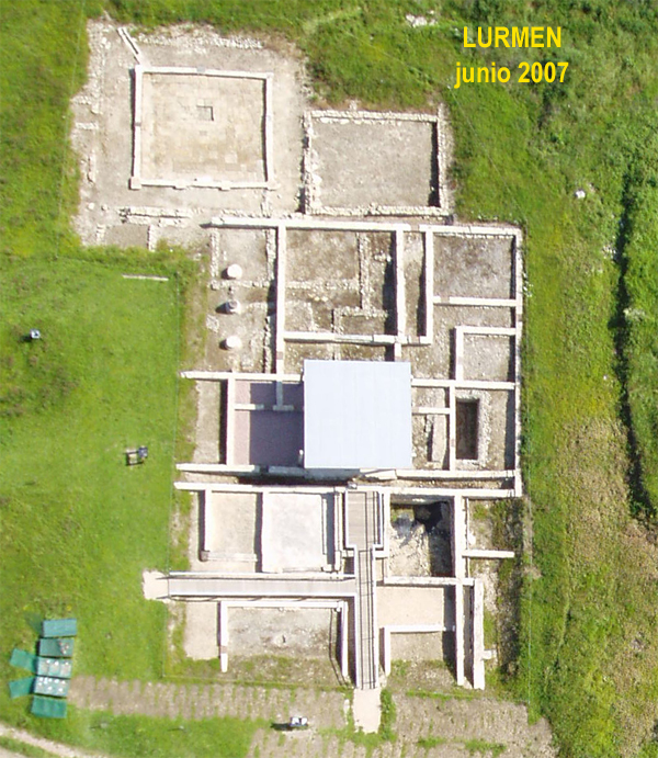
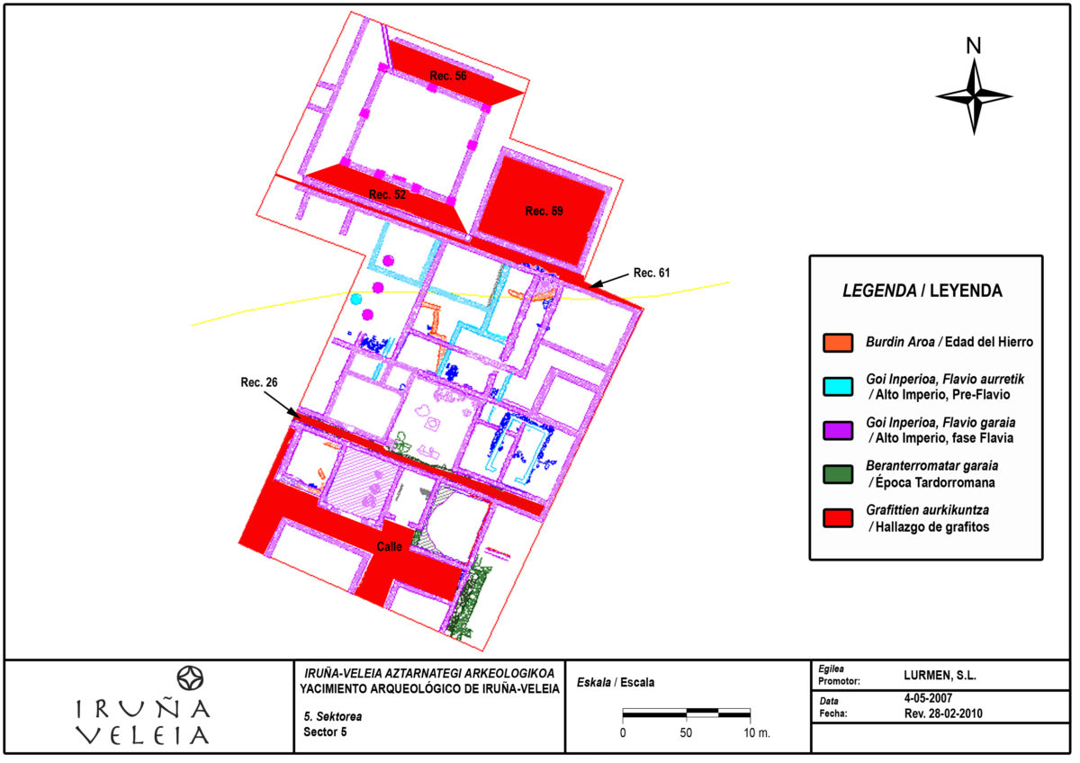
Inicialmente, de este sector sólo se conocía la presencia de un impluvium o patio, dotado de un mosaico bícromo de círculos secantes, con una cisterna con cubierta de bóveda de medio punto bajo él, dotada de revestimiento hidraúlico y baquetón de limpieza. Fue localizado fortuitamente en los años 60 durante unas tareas de laboreo agrícola. En torno a este patio, se excavó en extensión un sector, el 5, bajo la dirección de E. Gil Zubillaga, hasta casi completar la planta de una gran residencia urbana -distribuida en torno a un atrio y un peristilo- y de la calle a la que se abría. Es el conjunto residencial urbano que mejor conocemos, dado que se han excavado de él casi 900 m2.
El espacio en que se edificará la Domus de Pompeia Valentina (DPV), fue ocupado en época prerromana, conservándose alguno de sus fondos de cabaña completo, bajo los niveles romanos. Una primera casa romana se contruirá, por tanto, sobre los derrumbes de las viviendas del poblado prerromano, cuyos datos más antiguos nos remontan a comienzos del Ier milenio a.C. Esta primera vivienda urbana se construyó en época preflavia, concretamente en torno a mediados del siglo I d.C., la cual fue prácticamente desmontada para construir la DPV, si bien subsistieron algunas cimentaciones y, sobre todo, una cisterna de opus caementitium u hormigón romano, en torno a la que se había distribuido la casa.
La DPV se edificó en época flavia, a fines del siglo I d.C. y permaneció en uso hasta mediados del siglo V d.C., registrándose en ella frecuentes reparaciones y modificaciones. En su configuración definitiva, se trata de una casa de grandes dimensiones que se articula en tres niveles de altura, aterrazándose para amoldarse a la ladera, de forma que el área distribuida en torno al atrio está más alta que la organizada en torno al peristilo y, a su vez, la zona de acceso, lo está respecto a la del atrio. Ese aterrazamiento se consiguió en base a la construcción de muros paralelos utilizados, además de como estructuras de contención, como canalizaciones al servicio de la casa.
Un primer nivel, lo constituía el acceso a la vivienda, junto al que se ubicaban unos recintos correspondientes a tabernae, las cuales se abrían a la calle. La fachada se adecúa al eje viario, adoptando una planta en escalera que se refleja en las tabernas que flanquean la entrada principal o fauces. Un segundo nivel de la casa, era el que se se distribuía en torno a un patio central abierto o impluvium, dotado de su correspondiente cisterna en el subsuelo. Este patio era de atrio, sin pasillo en torno a él, de forma que de él se accedía directamente a las habitaciones, que muestran una cierta simetría lateral, con dormitorios a ambos lados del patio. Un tercer nivel lo constituye la parte trasera de la domus, donde se concentran los espacios representativos de la vivienda, entre los que destacaría una galería porticada o peristilo, dotado de un pavimento de grandes losas, en torno al que se distribuían dichos espacios y, entre ellos, el denominado recinto 59. Finalmente, en el ángulo sur, junto a un afloramiento rocoso, se han identificado dependencias domésticas.
El momento de máximo esplendor de esta residencia fue el siglo II e incluso parte del III d.C., evidenciándose su ruina generalizada en torno a la 2ª mitad de esta centuria. Aún tuvo una reocupación posterior de alguno de sus espacios, concretamente, sobre los escombros del peristilo se produjo una ocupación en época tardorromana, en torno a mediados del siglo IV, perdurando hasta algún momento de la centuria siguiente. Esta ocupación sólo se conserva a nivel de subsuelo, habiéndose localizado incluso una inhumación infantil correspondiente a esta última fase. Además, una de las antiguas tabernae instaladas en la fachada de la domus, fue reutilizada como basurero.
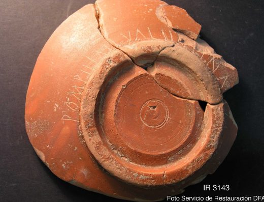
Entre los recintos excavados destacaríamos, por haberse localizado en ellos un numeroso conjunto de grafitos excepcionales, el 59. Otros grafitos que también podemos considerar excepcionales, se localizaron de forma aislada en otros recintos, como el 26, 52, 56 y 61. No guardarían relación con los del recinto 59, exceptuando quizás los localizados en los recintos 52 y 61, localizados en el mismo contexto general del derrumbe de la parte N. de la casa y correspondientes, por tanto, a similar cronología. Entre estos grafitos aislados, incluiremos aquél que da nombre a la casa, el de Pompeia Valentina, localizado entre los escombros caídos sobre la calle al S. de la domus aunque no se trataría, propiamente, de un grafito excepcional.

Gran recinto de algo más de 58 m2 de superficie, ubicado en la terraza norte, junto al pasillo E. del área residencial distribuida en torno al peristilo y delimitada al sur por uno de los canales que marcan además un cambio en el nivel de suelo de la misma. A juzgar por los restos conservados, este recinto 59 no tendría acceso directo desde él sino que, probablemente, se entraría directamente desde el área residencial distribuida en torno al atrio. Los datos estructurales del recinto 59 nos permiten proponer como hipótesis que dicha habitación pudo tener un piso principal cuyo suelo -presumiblemente de madera- estaría a la cota del atrio y, un piso inferior o semisótano con una cota similar a la del enlosado del peristilo. Sus muros perimetrales, -cerrados, en la parte inferior conservada- mostraban una protección antihumedad, en forma de revestimientos de arcilla y, en dos de ellos, con lajas de caliza dispuestas verticalmente unidas -también con arcilla- al propio muro. Se identificaron varios momentos de uso en este recinto, instalado sobre niveles de ocupación prerromanos. La habitación se construyó en torno a fines del I-principios del II, correspondiendo por tanto a la fase de ampliación de la DPV. No se conservan los niveles de ocupación de este momento, pero sí del siguiente. Y es que a fines del II-principios del III, se produjo una reforma en el recinto, por la que se le dotó de los revestimientos antihumedad y de un nuevo suelo, eliminando el anterior. Este recinto, sufrió un colapso en la 2ª mitad del siglo III, que no fue exclusivo de él sino que se detecta, especialmente, en toda la zona norte de la domus. Se localizaron grafitos excepcionales en la fase correspondiente al colapso del recinto, concretamente en el nivel inferior de derrumbe sobre el suelo (SU: 51144). Las características y ubicación del recinto, así como el material localizado en él, nos llevaron a proponer, como hipótesis interpretativa que estábamos ante una estancia dedicada a servir de paedagogium. Sin embargo, ésta es sólo una hipótesis de trabajo que habrá de ser confirmada, matizada o contradicha, tras el estudio en profundidad del material gráfico y epigráfico en ella localizado.
Canal sur de la domus. A su vez era la estructura de contención del aterrazamiento de esta parte de la casa, concretamente entre su zona de acceso fauces/tabernae y el área distribuida en torno al atrio. Se localizó de forma aislada un grafito excepcional en este canal, concretamente en su relleno de amortización formado cuando el canal ya estaba en desuso, en algún momento del siglo III d.C.
Pasillo sur del peristilo de la zona N. de la domus. Se localizó aquí de forma aislada algún grafito de carácter excepcional en el nivel de derrumbe generalizado de la zona, producido en la 2ª mitad del siglo III d.C., así como en un nivel de suelo de época altoimperial.
Pasillo norte del peristilo de la zona N. de la domus. Se localizó aquí de forma aislada un grafito en el nivel superior de remoción agrícola. Lo incluimos por su proximidad al recinto 59.
Canal norte de la domus. A su vez era la estructura de contención del aterrazamiento de esta parte de la casa, concretamente entre el área distribuida en torno al atrio y la organizada alrededor del peristilo. Se localizó de forma aislada un grafito excepcional en este canal, concretamente en su relleno, formado en el momento del derrumbe generalizado de la 2ª mitad del siglo III d.C.
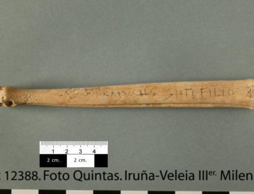
Vial situado al sur de la domus y al que se abrirían las fauces o acceso a la misma, así como las tabernae situadas en este frente de fachada. Se localizó de forma aislada un grafito entre el derrumbe caído sobre la calle hacia el siglo III d.C.. Aunque no se trataba de un grafito de carácter excepcional, lo incluimos aquí ya que fue el que nos dió un nombre con el que identificamos la casa.
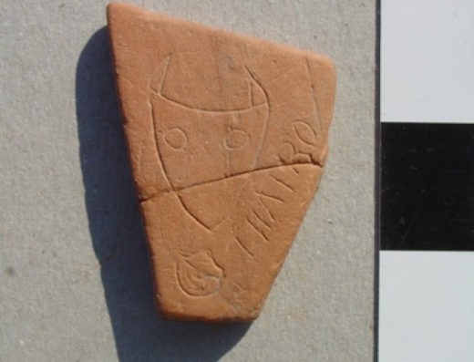
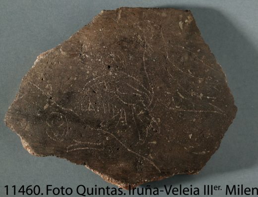
Aparecieron un total de 705 graffiti en este sector distribuidos en distintas UUEE. De ellos, 300 se localizaron en el denominado recinto 59, de los cuales se registraron 289 en la UE 51144, formando -en su mayor parte- un conjunto coherente -pese a la aparente disparidad temática-, creado en un momento cronológico concreto. Como ya hemos explicado en la introducción, no todos estos grafitos eran excepcionales ni todos tenían por qué formar parte del conjunto propiamente dicho. No obstante, presentamos aquí un total de 203 grafitos de los 289 de la UE, esto es, todos, exceptuando únicamente los formados por trazos sin más. Y lo hacemos sin más selección para obtener una visión global del hallazgo.
Consideramos que los grafitos de la UE 51144 formarían parte -en su mayoría- de un conjunto con un horizonte cronológico bien marcado. Y lo consideramos un conjunto (con grafitos excepcionales y otros que no lo son) porque pensamos que este material gráfico se ejecutó en un contexto determinado y de forma más o menos coetánea, en un momento cronológico previo al colapso de la estructura que los dejó enterrados. Ahora bien, somos conscientes de que algunos de los grafitos identificados no formarían parte de este conjunto, sino que habrían sido ejecutados con anterioridad y en otro contexto. Éstos no tendrían nada que ver con el conjunto en sí. De hecho, se detectaron piezas con un grafito atribuible al momento de uso del recipiente y otro u otros, grabados cuando dicha pieza ya estaba rota y amortizada y que sí formarían parte del conjunto gráfico. Esto tiene una explicación bien obvia. Si, como pensamos, el material arqueológico fue aportado al recinto durante su funcionamiento, posiblemente desde un basurero, era perfectamente factible que dicho material tuviera ya algunos grafitos grabados.
Al margen de los grafitos de la UE 51144, en el sector 5 se localizaron de forma aislada algunos grafitos excepcionales más, de los que hacemos una drástica selección y nos referiremos a su contexto de forma somera. Se trata de un total de 11 grafitos, concretamente 1 de los 4 localizados en la UE 5079 del recinto 26, 1 de los 11 localizados en la UE 5851 del recinto 52, los 2 localizados en la UE 5919 del recinto 52, el localizado en la UE 5001 sobre el recinto 56 y los 5 localizados en la UE 51184 del recinto 61. Incluiremos no obstante un grafito localizado en la UE 5139-B -sobre la calle-, puesto que es el que nos proporcionó un nombre con el que identificar, si se quiere, en un sentido humano, la vivienda, si bien no se trata propiamente de un grafito excepcional.
Por tanto y con respecto a la cronología, hemos de tener en cuenta que la que aquí se ofrece es la correspondiente al momento de formación del estrato. Esto es extensible al resto de los grafitos del sector 5 que también incluimos. Eso nos proporcionaría la datación ante quem de los grafitos. No hay que perder de vista que, en el caso de los que presentamos aquí, corresponden a niveles de derrumbe y de amortización de los espacios, donde el material arqueológico se encuentra en disposición primaria, por lo que podemos suponer que el momento de grabado de los grafitos, sería bastante próximo al momento de formación del estrato o algo anterior (con límite cronológico en la fechación del estrato subyacente, en cada caso). Como ya hemos visto, el caso de la UE 51144 es un poco especial porque cuenta con material aportado de otro lugar a una posición secundaria, por lo que hay grafitos correspondientes a una fase anterior. Sin embargo, la reutilización de parte de este material como soporte de escritura o de dibujo, les proporciona una reubicación estratigráfica que acotaría su datación en relación a la formación del nuevo estrato en el que, finalmente, quedan depositados en la estratigrafía. Es decir, al reutilizarse el material, este segundo momento en su uso (al ser reutilizados como soporte) les otorgaría una nueva ubicación primaria en la secuencia estratigráfica.
Estrato inferior del derrumbe caído sobre el suelo del recinto.
Relaciones estratigráficas: Se adosa a las UUEE 5912 / 5952 / 51146 / 51193 / 51194 (5912 y 5952 revestimientos de lajas de los muros; 51193 y 51194 revestimientos de arcilla de los muros; 51146 muro lado norte en la parte en que había perdido el revestimiento). Situada bajo la UE 51143 (estrato de derrumbe) y cubriendo a la 51187 (interfase de suelo).
Chronology: 2ª mitad siglo III d.C.
C14 dating
• Ref. Gr.N-29997 (IR-11088): 1925 ± 15 BP (25 d.C. ± 15). Calibración a 2 sigma 95%: 33-35 d.C./53-90 d.C./101-125 d.C. Se trata de una muestra de madera carbonizada, que entra dentro del rango cronológico proporcionado por el resto de las evidencias materiales del nivel. Hay que tener en cuenta que la fecha correspondería al momento en que se formó la parte del árbol de la que se extrajo la tabla, el puntal, etc.
• Ref. Gr.N-29999 (IR-15006): 1820 ± 60 BP (130 d.C. ± 60). Calibración a 2 sigma 95%: 65-345 d.C./373-376 d.C. Se trata de una muestra de fauna. Tanto ésta coom las siguientes, encajan dentro del rango cronológico proporcionado por el resto de las evidencias materiales del nivel. Confirmarían también el hecho de que se produjo un aporte de material de desecho (basura) de los siglos I y II d.C. a un estrato formado en el siglo III. Incluso tomando en consideración la fecha más extrema que nos proporciona la calibración, tendríamos una datación extrema en el siglo IV, desestimable por lo que hemos señalado, pero romana, no obstante.
• Ref. Gr.A-31246 (IR-15007): 1905 ± 30 BP (45 d.C. ± 30). Calibración a 2 sigma 95%: 26-43 d.C./47-140 d.C./153-169 d.C./195-210 d.C. Se trata de una muestra de fauna, datada por AMS.
• REf. Gr.N-29998 (IR-15008): 1940 ± 40 BP (10 d.C. ± 40). Calibración a 2 sigma 95%: 38-7 a.C./2 a.C-131 d.C. Se trata de una muestra de fauna.
Calibrations
Las calibraciones ofrecidas, a partir de las fechaciones BP del laboratorio de Isótopos de la Universidad de Groningen (referencias Gr.N=fechaciones convencionales C14; GR.A=fechaciones por acelerador AMS) se han obtenido a partir de la aplicación WinCal25 (transformation of a radiocarbon date BP into a calender year probability distribution (Cal AD/BC), del Centre for Isotope Research, University of Groningen, The Netherlands, J. van der Plicht, version 1.4 16 november 2007 AD (-57 BP), http://wincal25.software.informer.com/. Adicionalmente ofrecemos también sus calibraciones a través de la aplicación OxCal 4.1, Christopher Bronk Ramsey, Oxford Radiocarbon Accelerator Unit, Research Lab for Archaeology, https://c14.arch.ox.ac.uk/oxcal/OxCal.html. Así tendríamos; IR-11088: 29-126 d.C. IR-15006: 65-377 d.C. IR-15007: 25-212 d.C. IR-15008: 45 a.C-136 d.C., siendo la probabilidad de certeza suministrada por este sistema del 95,4%.
Interpretation
Vamos a detenernos someramente en los aspectos relativos a la interpretación (que no a la secuenciación -base de datación-) de este estrato, dado que ha sido sometida a un debate que consideramos un tanto fuera de lugar. Aportaremos nuestro punto de vista fundamentado en algo insustituible como es la inspección visual in situ, los datos de primera mano de que disponemos, la experiencia en campo y el conocimiento del propio yacimiento. Insistimos no obstante, que es la secuenciación del estrato, esto es, su ubicación en el registro estratigráfico, lo que proporciona las bases de su datación (junto con el material asociado). La interpretación, como la propia palabra indica, entra en un terreno más reconstructivo y, por tanto, más subjetivo; si bien, no obstante, debe estar basado en datos fiables y no en supusiciones sin más, como creemos se ha hecho para intentar desacreditar nuestra propuesta, sin lograrlo. Por otra parte, variar las interpretaciones en el proceso de una excavación es algo no sólo habitual, sino totalmente normal e incluso necesario. Porque el aporte de nuevos datos cuando el trabajo de campo y de estudio está en marcha, o los propios procesos de reflexión inherentes en toda investigación, obligan en muchos casos a replantearse las hipótesis de partida. Cuál es el problema? Nosotros les respondemos: ninguno. El problema es agarrarse cerrilmente a una interpretación inicial y, como tal, provisional.
Veamos. Bajo la capa de remoción agrícola (SU: 5001), detectamos el mismo nivel generalizado de derrumbe, compuesto por grandes lajas, que habíamos identificado en el resto de la zona N. de la casa. En este área este derrumbe se denominó UE 51143. Bajo él encontramos otro estrato directamente depositado sobre un suelo. Suelo muy evidente por su propia compactación y nivelación (SU: 51197 con su interfase UE 51187). Este nivel, identificado estratigráficamente como UE 51144 estaba contenido dentro de los límites del recinto 59. En primer lugar señalaremos por qué interpretamos este estrato como un nivel de derrumbe. El estrato tenía una composición heterogénea, característica habitual en derrumbes en los que el proceso de colapso estructural aporta materiales constructivos de distinta índole, provenientes -lógicamente- de construcciones en las que se utilizaron elementos diversos (piedra, adobe y madera, por ejemplo). El ojo experto formado en arqueología de campo, permite distinguir perfectamente cuándo la heterogeneidad corresponde a una misma unidad estratigráfica o a varias. En este caso, era clarísimo que era una única unidad. Se trataba de material constructivo derrumbado y caído in situ, aportando el distinto material que componía la estructura a la formación del estrato, resultando zonas de distinta composición y coloración con límites difusos, no definidos como hubiera sido propio de unidades diferentes. Así, había zonas más adobosas junto a los muros del E. y W., evidenciando la caída de elementos constructivos compuestos de arcilla provenientes, con toda probabilidad, de estos mismos muros (posiblemente de sus recubrimientos sin descartar una posible composición arcillosa de los propios muros, al menos parcial, como hemos visto en los levantes de otros muros en este mismo sector). Esas zonas más adobosas caídas claramente in situ, se iban difuminando para dar paso a otras más carbonosas, donde lo que había era un mayor aporte de madera. Todo lo cual nos parece una evidencia clara de que se trata de un nivel de derrumbe. A ello se uniría la presencia de abundantes mampuestos en el estrato, de los habitualmente usados en las construcción de los muros del yacimiento.
Ahora bien, al principio, no desechamos ninguna hipótesis interpretativa, barajando todas las posibles y, entre ellas, que se tratara de un relleno, tal y como expusimos en el Informe original. Sin embargo, enseguida desechamos esta posibilidad porque un relleno, considerado como actuación antrópica por la que se produce un aporte de tierra (que puede incluir materiales) para rellenar o colmatar un espacio, no hubiera presentado jamás las características de la UE 51144. Sobre la tan traída y llevada cuestión de que este estrato se interpretara como derrumbe de las estructuras de alzado, no vemos dónde está el problema. Los derrumbes no caen según nos indica un manual. Hay muchas circunstancias que pueden incidir en el hecho de que encontremos restos caídos de alzado por debajo de restos caídos de techo. Además, posiblemente el derrumbe no se conservaba completo y hayamos perdido otras capas de escombro superiores que hubieran permitido una mejor definición del proceso de colapso estructural. El hecho es que la UE 51144 tenía en su composición arcilla (especialmente concentrada junto a dos muros), restos de madera (especialmente en la zona central) y mampuestos generalizados en su composición. No podemos desechar tampoco que a la generación de dicho escombro hubiera podido contribuir como apuntábamos en nuestro informe “la ruina de su techo y forjado de madera y de parte del recubrimiento de arcilla de sus paredes”, en referencia a la posible existencia de un semisótano. En cualquier caso, la presencia de mampuestos apunta a la caída, al menos parcial (posiblemente por algún fallo estructural) de alguno de los alzados. Por eso en general, concluimos que la UE 51144 era un nivel de derrumbe de las estructuras de alzado (muros, revocos de arcilla e incluyendo, en el caso de haber existido, el suelo de madera). Y encima tenía otro estrato con grandes lajas adscribibles a una cubierta. El resto del escombro que probablemente hubo por encima de los niveles conservados, lo desconocemos. Creemos que los datos y los indicios conservados, apuntarían hacia nuestra propuesta reconstructiva del proceso de derrumbe, como la más lógica con los datos disponibles.
Pero sobre qué cayó este derrumbe? Tenemos dos opciones: o directamente sobre el suelo de arcilla apisonada identificado en el proceso de excavación, o sobre un posible suelo de madera que tuvo que quedar destruido en el proceso, con lo cual, finalmente, el escombro habría terminado cayendo sobre el suelo de arcilla, único conservado en el registro estratigráfico. Evidencias someras y no definitivas de dicho entarimado de madera podrían ser los restos de madera dispersos por todo el estrato si bien concentrados en su parte central.
Por otro lado, tenemos el cuantioso volumen de evidencias materiales de época romana localizadas en el nivel, las cuales marcan un arco cronológico entre mediados del siglo I al III d.C., siendo las evidencias más abundantes las del II y, ya muy puntuales, las del III, que son las que permiten acotar el momento de formación del estrato. Propusimos como hipótesis que este material había sido aportado de forma intencionada a este recinto. Y por ello inicialmente se barajó la posibilidad de que podía haber sido traido junto con tierra como relleno. Pero ya hemos visto que la composición del estrato apuntaba hacia un nivel de derrumbe con lo cual, consideramos más probable que se tratara de material aportado para su almacenamiento (quizás desde un basurero cercano), sin ningún tipo de proceso de selección previa. Además, la aparición de los grafitos, muchos de ellos grabados sobre material ya fragmentado, nos hizo proponer la hipótesis de que se trataba de material almacenado para tener dónde seleccionar fragmentos luego utilizados como soporte de escritura. Si este material estaba almacenado en un semisótano o no, es algo que no se puede demostrar con absoluta certeza. Pero tiene una importancia muy secundaria. En cualquier caso, estaba sobre el suelo de arcilla. El caso es que, en el proceso de derrumbe, el material que estuviera depositado sobre el suelo de la estancia (sea directamente sobre el suelo de arcilla, sea sobre un hipotético suelo de madera) quedó incorporado al nivel de escombro formado, mezclándose con los propios elementos aportados por el derrumbe. Es decir, el material no cayó con éste, sino que era el que estaba en el suelo, almacenado o en uso, el cual, a consecuencia de un hecho violento como es un derrumbe, quedó incorporado en un estrato de escombro que es el que, arqueológicamente identificamos.
Para nosotros, por tanto, está claro que estamos ante un derrumbe. Pero no podemos dejar de señalar una cuestión que se ha señalado con respecto a este estrato. Y es que se ha indicado que las coloraciones diferentes registradas en él (sobre todo en relación a la mancha carbonosa central), podían indicar una posible alteración postdeposicional no detectada en el proceso de excavación. Esta afirmación no puede dejar de asombrarnos por su gratuidad, por ser totalmente infundada y por no poderse demostrar. Una alteración postdeposicional es algo que se evidencia de forma patente al excavar, precisamente porque modifica la secuencia de forma traumática. Estas alteraciones siempre tienen límites bien definidos -como toda fosa- y no respetan los estratos. Nos explicamos. Cómo entender una alteración post-romana en la estratigrafía del recinto 59, que no hubiera alterado el nivel superior UE 51143, que sí hubiera afectado al siguiente UE 51144 y sólo a éste ya que tampoco había alterado ni siquiera al suelo subyacente UE 51197? Como entender una alteración postdeposicional en forma de una mancha negruzca, cuya aparición se limita a un único estrato, cuyos límites se difuminan y cuya composición evidencia claramente una formación arqueológica? Y que, por añadidura, esta suposición venga hecha por quienes no han visto de forma directa la excavación ni consultado los datos de campo, es algo realmente insostenible. Por tanto, esta posibilidad debe quedar descartada.
Es obvio que puede haber otras opiniones al respecto que respetamos, pero si están argumentadas y fundamentadas en datos de los que nosotros aquí, sólo hemos podido esbozar unos ligeros apuntes. Porque hay que tener en cuenta muchos otros aspectos de carácter estructural (por ejemplo, cómo se incardina este recinto con el resto de la construcción de la domus) y tener en cuenta un sin fin de datos e indicios que no podemos explicar aquí y que corresponde a la memoria de excavación propiamente dicha.
Los grafitos que a continuación se exponen aparecieron de forma aislada, no formando parte de un conjunto como el visto anteriormente.
Relleno de amortización del canal S. de la domus cuando éste estaba ya en desuso.
Relaciones estratigráficas: Bajo las UUEE 5001 (estrato de remoción agrícola) y 5177 (relleno puntual de colmatación del canal). Rellenaba a la UE 51297 (interfase del hueco del canal)
Chronology: siglo III d.C.
Estrato de derrumbe generalizado sobre el peristilo. El grafito en cuestión se localizó en el pasillo S. del mismo o recinto 52.
Relaciones estratigráficas: Bajo la UE 5001 (estrato de remoción agrícola) y sobre la UE 5904 (estrato de ocupación).
Chronology: 2ª mitad del siglo III d.C.
Estrato de preparación del suelo del pasillo situado al S. del peristilo.
Relaciones estratigráficas: Bajo la UE 5122 (interfase de suelo) y sobre las UUEE 5921 (estrato de ocupación anterior a la construcción del peristilo de mediados del I d.C.), 51042 y 51027 (fosa de saqueo y relleno de fines del I d.C.).
Chronology: Época romana altoimperial, siglo II d.C.
Estrato de remoción agrícola generalizado a todo el sector.
Relaciones estratigráficas: En el recinto 56, cubría a la UE 5983 (estrato de ocupación) y a la UE 5981 (cimentación del muro de cierre del recinto 56 por el norte).
Chronology: El soporte del grafito es claramente romano, pero la estratigrafía no aporta datos cronológicos al tratarse del estrato superficial.
Relleno del canal N. de la domus, producido en el momento del derrumbe y formado con la aportación de éste.
Relaciones estratigráficas: Bajo la UE 5001 (estrato de remoción agrícola) y rellenando a la UE 51183 (interfase del hueco del canal).
Chronology: 2ª mitad el siglo III d.C.
Estrato de derrumbe generalizado sobre la calle al S. de la DPV.
Relaciones estratigráficas: Bajo la UE 5139-A (parte superior de este estrato derrumbe) y sobre la UE 5139-C (parte inferior de este estrato de derrumbe)
Chronology: siglo III d.C.

