AUDIO-GUIDE IN Spanish (sintetizada) 1 minuto 30 segundos
AUDIO-GUIDE IN ENGLISH (sintetizada) 1 minuto 30 segundos


AUDIO-GUIDE IN Spanish (sintetizada) 1 minuto 30 segundos
AUDIO-GUIDE IN ENGLISH (sintetizada) 1 minuto 30 segundos
By Idoia Filloy Nieva and Eliseo Gil Zubillaga
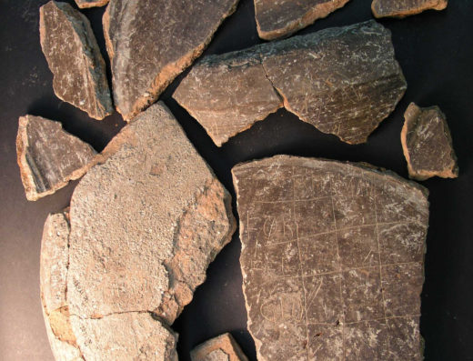
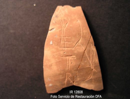
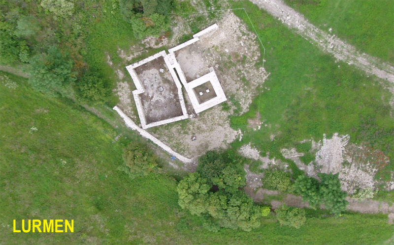
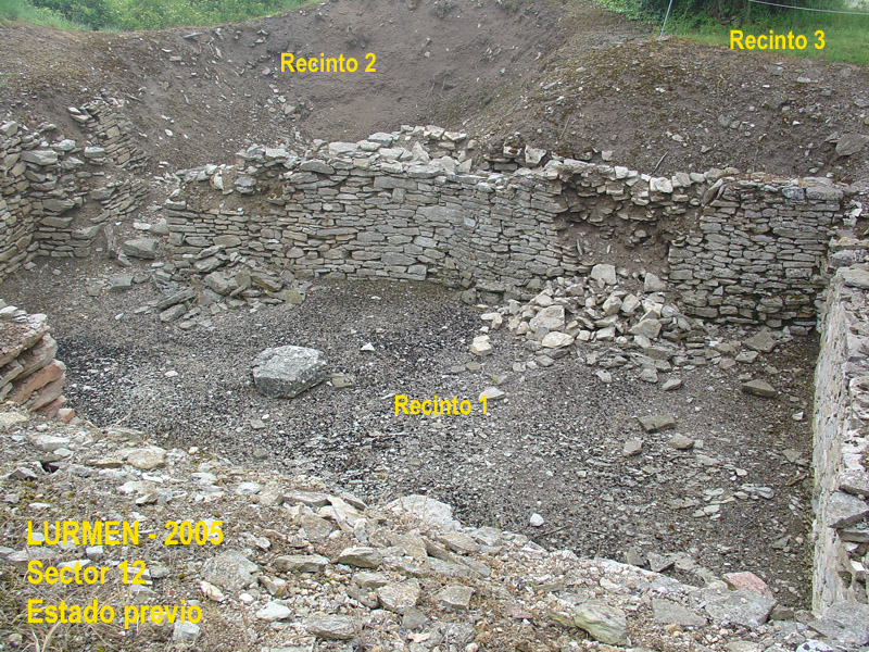
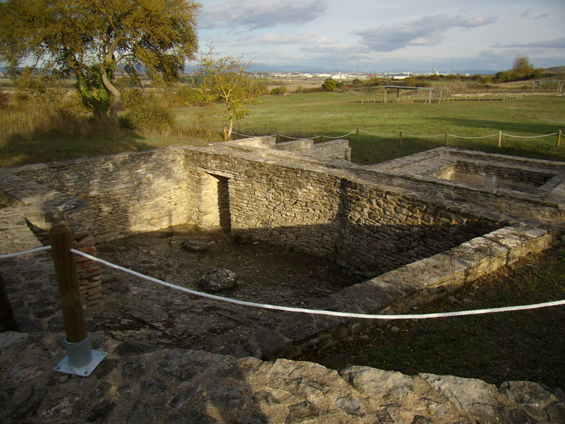
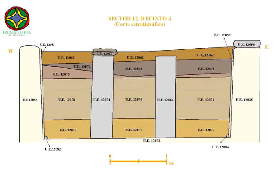
Corresponde a uno de los antiguos sectores de excavación de G. Nieto (1949-1954), quien localizó allí los restos de un edificio ubicado junto al cardo o calle principal N.-S. de la ciudad. En este punto, dicho edificio se conservaba a nivel de subsuelo, de forma que excavó un recinto completo (el 1) y gran parte de otro (el 2), correspondientes a un sótano, compuesto por dos estancias, accediéndose de la una a la otra a través de una puerta conservada. También excavó un recinto estrecho (el 7). Durante las excavaciones de E. Gil Zubillaga, concretamente en el año 2005, se excavó otro recinto completo (el 3) -situado junto al anterior-, correspondiente a una cisterna cuyas paredes se conservan en toda su altura, habiéndose localizado en su interior el derrumbe intacto de la cubierta, que estaba sustentada por dos pilares. Bajo el derrumbe, producido en el siglo V d.C., se localizó un interesante depósito efectuado de forma previa a la ruina de la estructura (SU: 12077), compuesto por restos animales (entre los que destacarían varios perros, aunque también había burros, caballos, cerdos, ovejas, cabras, conejos o gallinas) y humanos en disposición secundaria. En este sector, además de los recintos señalados, son visibles los arranques de las estructuras de otros aún sin excavar (el 4, 5, 6 y 8). Comentaremos brevemente los recintos en los que aparecieron grafitos de carácter excepcional.

Estructura conservada bajo el nivel de suelo de época romana y correspondiente a un sótano. Excavado por G. Nieto, casi por completo. Parte de los grafitos excepcionales de este recinto se localizaron en el derrumbe de los cantiles producido tras estas excavaciones hacia el interior del recinto, en la UE 12030. El resto, se localizó en su parte N. excavada por E. Gil Zubillaga, concretamente, en las UUEE 12001 y 12031, identificadas sobre el muro de cierre septentrional del recinto y correspondientes, al nivel de revuelto y a un derrumbe de en torno al siglo III d.C., respectivamente.
Estructura conservada bajo el nivel de suelo de época romana y correspondiente a una cisterna de agua. Excavada por completo durante las excavaciones de E. Gil Zubillaga. Se localizaron grafitos excepcionales en los niveles de relleno y derrumbe tardorromano de la misma, concretamente en las UUEE 12046, 12073, 12075 y 12076-B, así como en el nivel de depósito ya comentado, SU: 12077, ligeramente anterior cronológicamente.
Al igual que las anteriores, estructura conservada bajo el nivel de suelo de época romana. De él sólo se trabajó, en las excavaciones de E. Gil Zubillaga, en una pequeña franja al S. del mismo. No podemos determinar por tanto, la funcionalidad de este recinto. Los grafitos excepcionales se localizaron en la capa de revuelto UE 12001 y en un nivel de ocupación de época romana altoimperial UE 12023.
Estructura conservada bajo el nivel de suelo de época romana. De él sólo se trabajó, en las excavaciones de E. Gil Zubillaga, en una pequeña zona al N. del mismo. No podemos determinar por tanto, la funcionalidad de este recinto. Los grafitos excepcionales se localizaron en un nivel de relleno UE 12050 y en otro relleno de una fosa de saqueo UE 12068, ambos de época tardorromana.
Aparecieron un total de 122 graffiti en este sector distribuidos en distintas UUEE. De ellos, consideramos excepcionales un total de 77: 2 de los 9 localizados en la UE 12001, 3 de los 4 localizados en la UE 12023, 27 de los 39 localizados en la UE 12030, 29 de los 36 localizados en la UE 12031, el único localizado en la UE 12046, el único localizado en la UE 12050, 1 de los 3 localizados en la UE 12068, 1 de los 2 grafitos localizados en la UE 12075, los 2 grafitos localizados en la UE 12076-B y 10 de los 13 grafitos localizados en la UE 12077.
Con respecto a la cronología, hemos de tener en cuenta que las que aquí se ofrecen son las correspondientes al momento de formación de cada uno de los estratos. Eso nos proporcionaría la datación ante quem de los grafitos. Pero no hay que perder de vista que si éstos corresponden a rellenos, por ejemplo, el material arqueológico puede encontrarse en disposición secundaria, con lo que la cronología de los grafitos pudiera ser anterior, teniendo como terminus post quem, la propia datación del soporte. Sin embargo, en el caso concreto de la UE 12077 que es un depósito que, posiblemente tenga unas connotaciones rituales, es muy posible que los grafitos sean prácticamente coetáneos al momento de su formación, ya que la mayoría están grabados sobre material tardío cuya producción está próxima al momento en que se depositó dicho relleno.
Hay que tener en cuenta que este sector había sido excavado en parte por G. Nieto, siendo el recinto 3 el único que excavamos nosotros por completo. Por ello, en su día, sólo presentamos como hallazgos excepcionales aquellos graffiti aparecidos en el interior de esta cisterna. Ahora mostramos aquí todos los grafitos que consideramos excepcionales localizados en este sector, si bien hay que tener en cuenta que los localizados en las UUEE 12001 y 12030, aunque grabados sobre material de época romana, no tienen la garantía de una datación estratigráfica ya que se localizaron en disposición secundaria. Lo cual explicamos en cada caso concreto. Ello no significa, en absoluto, que no se trate de grafitos de época romana, sino que su ubicación en la secuencia estratigráfica cuando fueron localizados, no permite asegurarlo.
Estrato de remoción agrícola.
Relaciones estratigráficas: estrato superficial, del que sólo quedaban restos sobre la UE 12031 (derrumbe) en el momento de la excavación de 2005, ya que en el resto del recinto había sido eliminado en época de Nieto.
Chronology: El soporte de los grafitos localizados en esta UE es claramente romano, pero la estratigrafía no aporta datos cronológicos al tratarse del estrato superficial
Estrato de derrumbe de los cantiles dejados por la excavación de G. Nieto en el recinto 2. No se extendía por toda su superficie, sino -sobre todo- por su parte N. y E., que era donde Nieto no había localizado los muros de delimitación del recinto y, por lo tanto, dejó cantiles de tierra que la erosión y el paso del tiempo fueron poco a poco derrumbando, formando una unidad estratigráfica nueva. Obviamente esa nueva unidad suponía el aporte de tierras que, originariamente, habían constituído el relleno arqueológico del recinto 2; así como de piedras de alguno de sus muros.
Relaciones estratigráficas: en el momento de su excavación en 2005, estaba en superficie y, bajo él, aparecía la roca natural.
Chronology: la formación del estrato sería posterior a 1954, ya que se configuró por el derrumbe parcial de los cantiles dejados tras la excavación de G. Nieto. El material era mayoritariamente de época romana si bien en disposición secundaria, al haber sido desubicado por la erosión de su originaria estratigrafía arqueológica. En cualquier caso, la estratigrafía no puede proporcionar aquí una datación fiable de los grafitos.
Estrato de derrumbe. Aunque en origen habría cubierto todo el recinto 2 y sus muros, su extensión, al llevar a cabo su excavación en 2005, se limitaba a la zona no excavada por G. Nieto. En la parte excavada por E. Gil, el estrato estaba intacto.
Relaciones estratigráficas: bajo la UE 12001 (nivel de remoción agrícola). Cubría los muros UE 12019 y 12032 (que delimitan el recinto 2 por el N.), así como estratos aún no excavados del interior del recinto 2 por el E.
Chronology: En torno al siglo III d.C.
Relleno superior de colmatación de la cisterna (recinto 3), adosado a otro más perimetral (SU: 12050)
Relaciones estratigráficas: bajo la UE 12001 (nivel de remoción agrícola). Cubría a varias unidades, concretamente, a las UUEE 12051, 12059, 12060 (correspondientes a rellenos subyacentes de la propia cisterna), a estructuras de la propia cisterna (a muchas de ellas, cubriéndolas sólo parcialmente), como serían la UE 12057 (muro S. de hormigón), las UUEE 12053, 12079, 12081, 12087, 12089 (algunos de los propios revestimientos hidraúlicos de la misma, que aparecían justo bajo este estrato), la UE 12092 (zapata S. de cubierta) y, finalmente, también cubría a la UE 12054 (interfase de hueco de la cisterna).
Chronology: época tardorromana (siglo V d.C.)
Estrato de derrumbe al interior de la cisterna.
Relaciones estratigráficas: bajo UE 12073 (estrato de derrumbe) y cubriendo a UE 12076 (estrato de derrumbe).
Chronology: época tardorromana (siglo V d.C.)
Estrato de derrumbe al interior de la cisterna. Segunda de las tallas practicadas a efectos de excavación de esta unidad, dada su gran potencia.
Relaciones estratigráficas: bajo UE 12075 (estrato de derrumbe) y cubriendo a UE 12077 (estrato de depósito).
Chronology: época tardorromana, siglo V d.C.
Relleno de depósito sobre el fondo de la cisterna (recinto 3)
Relaciones estratigráficas: bajo UE 12076 (estrato de derrumbe) y cubriendo a la UE 12054 (interfase de hueco de la cisterna), situada sobre la UE 12078 (solera de hormigón de la cisterna).
Chronology: época tardorromana (siglo V d.C.), si bien el depósito se efectuó de forma previa al derrumbe de la cubierta de la cisterna.
Fecha C14 Ref. GrN-31584: 1630+/-40 BP (320 d.C. +/-40) (Cal. WinCal25, 2sigma, 95%: 339-539 d.C. OxCal4.0, 95,4%: 267-540 d.C.). Muestra ósea de uno de los individuos enterrados, en disposición secundaria en la cisterna y proveniente, muy probablemente, de una inhumación del siglo IV.
Estrato de remoción agrícola.
Relaciones estratigráficas: estrato superficial que cubría, en el recinto 4, a la UE 12024 (derrumbe).
Estrato de ocupación. Sólo identificado en una pequeña zona, al S. del recinto, ya que el resto está sin excavar.
Relaciones estratigráficas: bajo la UE 12024 (derrumbe) y sobre la UE 12026 (interfase de suelo).
Chronology: época romana altoimperial.
Relleno superior de amortización, ubicado perimetralmente respecto a la cisterna (recinto 3) y que también cubría el recinto situado al S. de la misma (recinto 8), al menos en la parte excavada.
Relaciones estratigráficas (en la zona del recinto 8): bajo UE 12001 (estrato de remoción). Cubría a varias UUEE: a un posible estrato de ocupación del recinto 8 (SU: 12063), a las fosas de saqueo de dos de sus muros (UUEE 12064 y 12069) y a sus correspondientes rellenos (UUEE 12068 y 12091).
Chronology: época tardorromana (siglo V d.C.)
Relleno de la fosa UE 12069. Fosa de época tardorromana para el saqueo del muro UE 12070, que delimitaba el recinto 8 por el E.
Relaciones estratigráficas: bajo UE 12050 (relleno de amortización) y rellenando la fosa de saqueo UE 12069.
Chronology: época tardorromana (siglo V d.C.)[/tp]

