AUDIO-GUIDE EUSKERAZ (laburpena: Estitxu) 2,30 minutu
AUDIO-GUIDE IN Spanish (sintetizada) 3,30 minutos
AUDIO-GUIDE IN ENGLISH (sintetizada) 1,30 minutos


AUDIO-GUIDE EUSKERAZ (laburpena: Estitxu) 2,30 minutu
AUDIO-GUIDE IN Spanish (sintetizada) 3,30 minutos
AUDIO-GUIDE IN ENGLISH (sintetizada) 1,30 minutos
By Idoia Filloy Nieva and Eliseo Gil Zubillaga
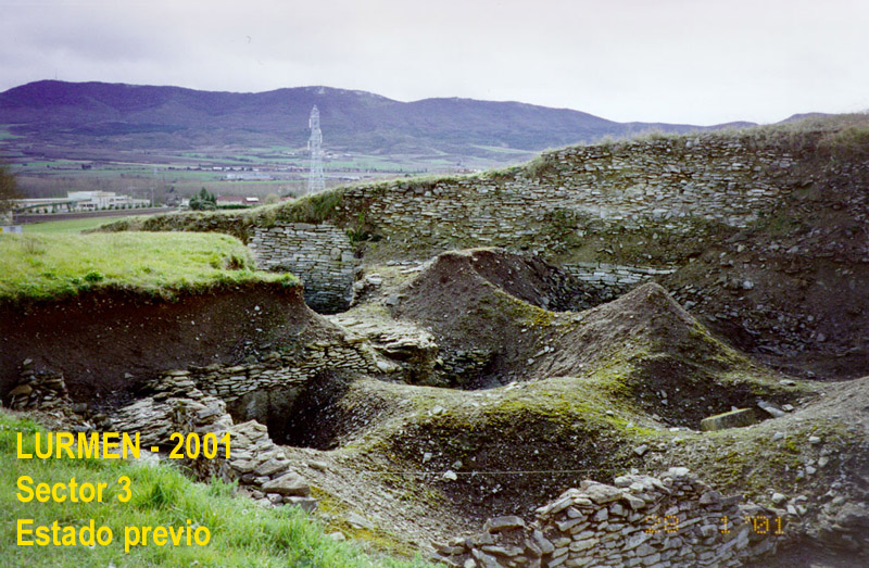
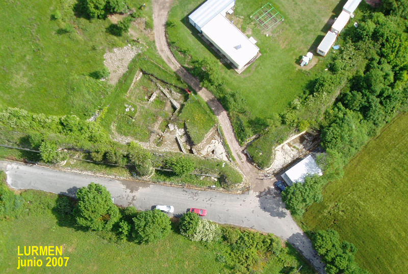
Este sector corresponde a la excavación del área junto a la puerta Sur de la muralla, construida en época tardorromana (en el tránsito entre los siglos III-IV d.C.) y que encerraba en su interior un caserío de más de 10 Ha. de las últimas fases de la ciudad de Veleia. En esta zona, la muralla presenta forro exterior de grandes sillares de caliza blanca (material al menos en buena parte reutilizado) y un núcleo de mampuestos calcáreos trabados con argamasa. A su vez la hoja interior está compuesta por mampostería de caliza trabada con argamasa, reforzada por hileras de sillares (cimentación y bandas horizontales) entre los que, nuevamente, destacan los elementos reutilizados. La puerta Sur está flanqueada por dos torres de planta semicircular. Sería una puerta monumental, con arco de medio punto, protegida por un rastrillo, del que aún subsisten los arranques de los carriles laterales. Las torres poseían un importante desarrollo en altura (aún se conservan mas de 9 m en algunos puntos). El espesor de los paramentos es también muy notable (entre 4,5 y 5,5 metros). En sus excavaciones, G. Nieto Gallo (1949-1954) desescombró gran parte de la muralla por su parte exterior.
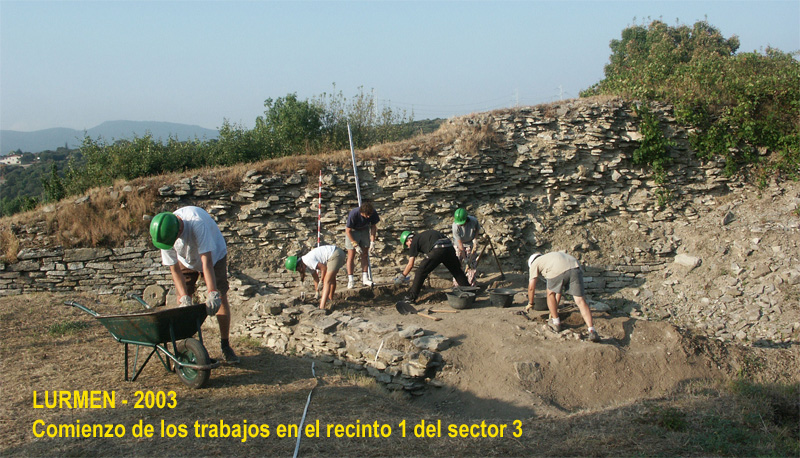
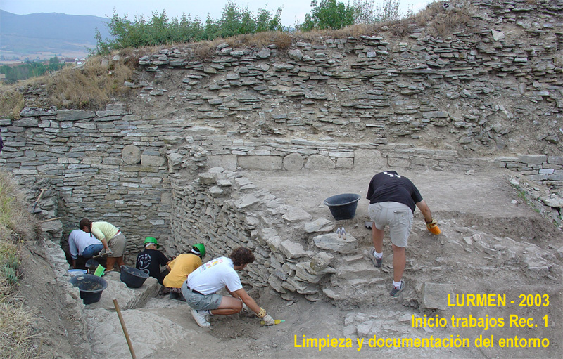
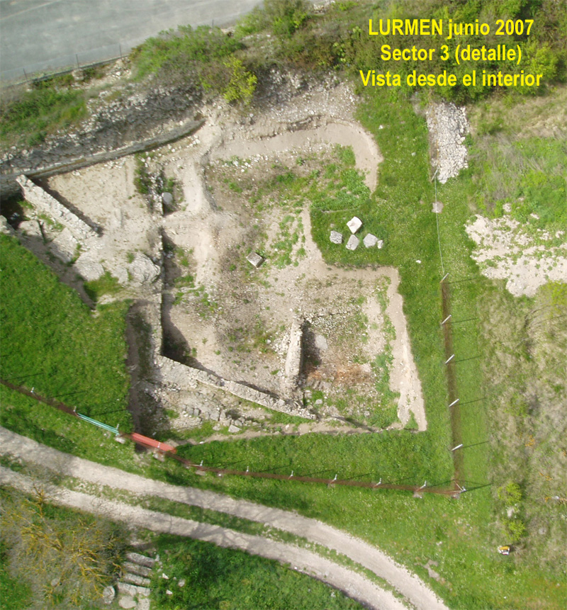
El área de excavación denominada como sector 3, se ubica concretamente junto a la torre oeste y en su parte intramuros. J.C. Elorza Guinea (1974-1975), llevó a cabo allí una excavación mediante el antiguo sistema Wheeler de cuadros que dejaban testigos entre ellos. No sabemos prácticamente nada de lo que se localizó en dichos trabajos, de los que sólo se veían algunos restos de muros y testigos ya arrasados por la erosión. Durante las excavaciones de E. Gil Zubillaga, concretamente en las desarrolladas entre 2003 y 2008, se eliminaron los testigos dejados por Elorza y se comenzó a trabajar en la parte intacta de un recinto (el 1) que éste no había terminado de excavar, así como en las áreas perimetrales de la antigua excavación de cara a su regularización. Fue aquí y en el recinto 1, donde aparecieron grafitos de carácter excepcional.

Recinto correspondiente a un posible espacio doméstico adosado a la muralla en época tardorromana, del que no es posible precisar más, al haber desaparecido sus niveles de ocupación, conservándose sólo a nivel de subsuelo. Excavado parcialmente por Elorza, que dejó una pequeña zona intacta, excavada despues por Gil Zubillaga. Sólo se conservaban sus límites S. -la propia muralla- y E. -que reaprovechó un muro adosado a ella y posiblemente construido como contención de las tierras adosadas a la misma a fines del III- (el otro muro que se observa en el plano en la parte W. del recinto tardío, no formaba parte del mismo, sino que era una estructura altoimperial localizada por Elorza y que marcaría uno de los cantiles de su excavación). No conocemos por tanto la superficie de este recinto cuando fue utilizado como espacio doméstico. Se trata, de un área con distintos usos a lo largo del tiempo ya que, cuando se construyó la muralla (sobre lo que había sido una antigua zona de ocupación urbana altoimperial), formaba parte del propio sistema estructural de la misma. De esta forma, los rellenos ubicados bajo el nivel de ocupación tardorromano, corresponderían a dicho sistema, posiblemente un aterraplenamiento de tierra sujeto por muros transversales o, incluso, una plataforma de acceso al servicio de la cara interna de la muralla. La zona no se excavó en toda su profundidad. Se localizaron grafitos excepcionales en los niveles de relleno para la preparación de suelo para la ocupación tardorromana, UUEE 3037-B y 3023, así como en un potente relleno relacionado con la construcción de la muralla, concretamente en la UE 3024.
Graphites and their contexts
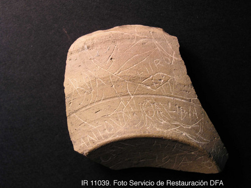
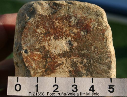
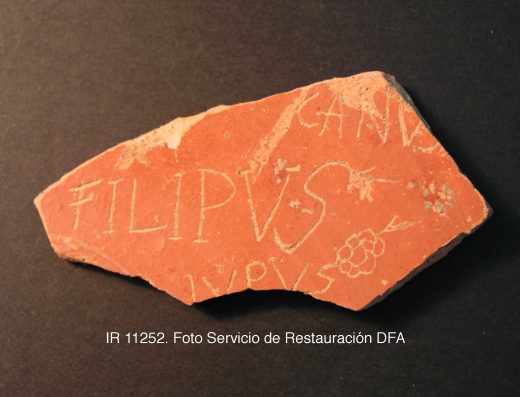
Aparecieron un total de 181 graffiti en este sector distribuidos en distintas UUEE. De ellos, consideramos excepcionales un total de 9: 1 de los 12 localizados en la UE 3001 (en la zona W. del sector), 5 de los 10 localizados en la UE 3037-B, 1 de los 8 localizados en la UE 3023 y 2 de los 22 localizados en la UE 3024-B. Obviamente, los grafitos excepcionales no constituyen aquí un conjunto, sino que aparecen de forma aislada entre otros. Además, al haberse localizado en tierras aportadas, desconocemos de qué contextos originales provienen.
Por tanto y con respecto a la cronología, hemos de tener en cuenta que las que aquí se ofrecen son las correspondientes al momento de formación de cada uno de los estratos. Eso nos proporcionaría la datación ante quem de los grafitos. Pero no hay que perder de vista que, en el caso del sector 3, éstos corresponden a rellenos, donde el material arqueológico se encuentra en disposición secundaria, con lo que la cronología de los grafitos pudiera ser anterior, teniendo como terminus post quem, la propia datación del soporte.
Señalar, finalmente, que alguna de las UUEE de este sector, se excavaron en varias tallas (denominadas con letras) dada su gran potencia. Las tallas no implican aquí más que una labor más detallada de documentación del estrato por profundidades.
(Ampliación zona W. del sector)
Estrato de remoción agrícola.
Relaciones estratigráficas: bajo la UE 3001 (capa superficial de remoción agrícola). Cubría a la UE 3074 (restos de un nivel, posiblemente aún de remoción) y a la UE 3076 (estrato intacto de amortización tardorromano).
Chronology: El soporte del grafito localizado en esta UE es claramente romano, pero la estratigrafía no aporta datos cronológicos al tratarse del estrato superficial.
Potente relleno adosado a la muralla, para nivelar la zona y asentar sobre ella un nivel de ocupación. Este nuevo espacio doméstico, aprovechó la propia muralla como cierre de uno de sus lados, así como lo que había sido una estructura relacionada con ella (SU: 3049), a la que este relleno también se adosó. No obstante, también se produjo un aporte postdeposicional de piedras provenientes del derrumbe de la muralla, incluso con posterioridad a las excavaciones del 70, en la parte superior del estrato.
Relaciones estratigráficas: esta UE aparecía directamente bajo el manto vegetal y bajo parte del escombro caído de la muralla. Cubría a las UUEE 3022 y 3023 (otros rellenos vertidos con el mismo fin). Excavada en dos tallas, habiendo aparecido los grafitos excepcionales en la inferior.
Chronology: época tardorromana (principios del siglo V d.C.)
Primer nivel de relleno adosado a la muralla, para nivelar la zona y asentar sobre ella un nivel de ocupación. Este nuevo espacio doméstico, aprovechó la propia muralla como cierre de uno de sus lados, así como lo que había sido una estructura relacionada con ella (SU: 3049) a la que este relleno también se adosó.
Relaciones estratigráficas: esta UE aparecía bajo la UE 3037 (relleno) y se asentaba sobre la UE 3120 (interfase correspondiente al reacondicionamiento de la zona que tuvo un uso anterior en relación al espacio defensivo adyacente a la propia muralla por su parte interna).
Chronology: época tardorromana (principios del siglo V d.C.)
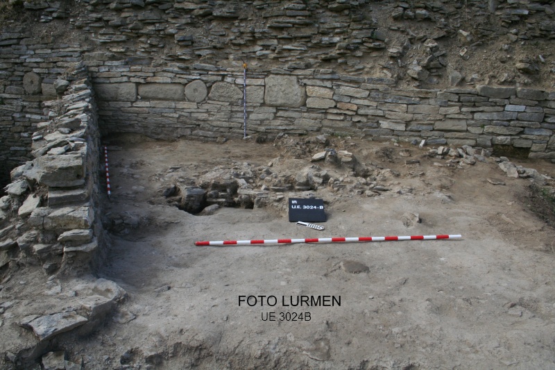
Potente relleno adosado a la muralla, aportado posiblemente con la finalidad de crear un aterraplanamiento o una rampa de acceso a la misma por su parte interior. El muro situado al E. (SU: 3049), al que este relleno también se adosó, posiblemente correspondía a una estructura de contención de las tierras aportadas.
Relaciones estratigráficas: bajo la UE 3120 (interfase de reacondicionamiento) y sobre la UE 3024-B (segunda talla de este mismo relleno). De éste se llegaron a excavar dos tallas, si bien había una tercera más sobre la roca, que no se terminó de excavar. Los grafitos excepcionales aparecieron en la parte superior del relleno.
Chronology: fines siglo III d.C.


